Early maps
The earliest printed maps, produced by Saxton (1577), Morden (1722) and others from the late 16th century onwards were usually drawn of individual counties and are of very limited historical use.
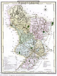
The first detailed maps
During the 18th century the need for new and improved mapping was created by developments such as the enclosure of common land, the commutation of tithes, and the planning and building of new turnpike roads and canals. By the end of the century published mapping had become much more detailed. Burdett's plan of Derbyshire (1767, revised 1791) is an example.
Enclosure and tithe plans
Mostly made during the period 1750 to 1850, they often provide the best map of a village or neighbourhood before the appearance of large-scale Ordnance Survey plans. Because of their manuscript format, the original plans will only be found at the Derbyshire Record Office, although some local libraries have microfilm or CD versions.
The Ordnance Survey
Although publication began in the early 1800s at the scale of 1 inch to 1 mile, the first plans of Derbyshire did not appear until around 1840.
The most useful maps for local studies are the large-scale plans at 6 inch, and later 25 inch to the mile, known as the County Series. Derbyshire sheets began to appear from the late 1870s. These maps are especially useful for study of a period of rapid population growth, extensive migration, industrial expansion and agrarian change with the associated development in transport.
Some of these maps are available in paper form but some are held on microfilm only.
Town plans and specialised mapping
Larger scale (usually 1:500) plans were also produced for towns of over 4,000 population. At this scale, street furniture is included, and the roofs of some public buildings are removed, to show internal layout. The towns in Derbyshire for which mapping was produced at this scale are Belper, Buxton, Chesterfield, Derby, Glossop, Ilkeston and Long Eaton.
Examples of all these different kinds of mapping can be found in Derbyshire's larger Local Studies libraries. Some historic and other local mapping can be found on the Derbyshire mapping portal.