A map is attached to this page. Or contact Tapton Lock Visitor Centre for a paper copy of the Archaeological Way leaflet, telephone: 01629 533020.
What you might see
The Archaeological Way is a wildlife spotter's delight.
Small mammals, insects and birds use the trails as wildlife corridors. If you're lucky you may spot a stoat or weasel hunting along the hedgerows.
Listen for the call of skylarks over the meadows or the yaffle of the green woodpecker in the woodland.
Look out for carpets of wild flowers. You'll see cowslips, yellow rattle and wild orchids in the grasslands or smell bluebells, wood anemones and ramsons (wild garlic) through the woodlands in spring.
Art along the way
We've worked with artists and communities to develop pieces that complement and enhance the landscape.
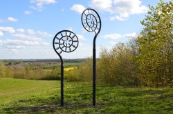
You can't miss the large fern sculpture at Poulter Country Park. There's also an installation as you cross the new bridge over the A623, and a mural in Pleasley painted by students from Anthony Bek School.
Why not try to find other pieces on the way?
More places to visit
Use the Archaeological Way and linking public rights of way to enjoy car-free journeys to local attractions such as Creswell Crags, Bolsover Castle, Sherwood Forest and Clumber Park.
Download the Archaeological Way app for more information and to help you explore.
How to find us
By train
You can reach the Archaeological Way from the Robin Hood Line, with stations at Langwith Whaley Thorns, Shirebrook and Creswell.
By car
If you're driving, Shirebrook town and Poulter Country Park are easily accessed off the A632 from junction 29 of the M1.
Parking
There are 2 car parks. One off Whaley Road between Whaley village and Langwith - follow the brown tourist signs.
In Whaley village the car park off Bathurst Terrace, serves both the country park and Langwith Whaley Thorns Railway Station.
In Shirebrook town there's charged parking at the railway station and parking at Kissingate Leisure Centre.